'Tornado' cloud pictured in Hartlepool on day of bizarre weather

and live on Freeview channel 276
A funnel cloud is an extending, spinning finger of cloud which is formed when a rotating column of wind draws in cloud droplets, making a region of intense low pressure visible.
They are formed in the same way as a tornado - and can become one if they touch the ground.
Advertisement
Hide AdAdvertisement
Hide AdScott Robson, of Hartlepool, captured the rare sighting on camera on Sunday, August 2, at around 4pm and says the spiral lasted for around five to 10 minutes.
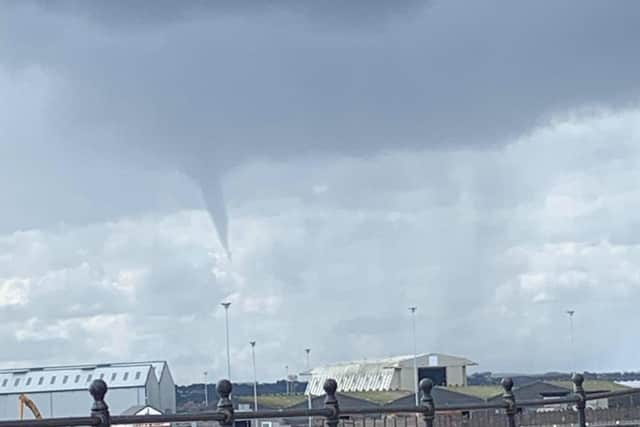

The 24-year-old said: “I was out walking with my fiancée and we had headed back to the car as the weather was very hit and miss.
"It started to rain heavily and when we got in the car I spotted it forming and then it went across the sky with the clouds.
"It was like it was in their path with them and then it sort of just fizzled out and disappeared after a bit.
Advertisement
Hide AdAdvertisement
Hide Ad“It’s definitely not something you see everyday is it. I’ve never seen one before in my life other than pictures elsewhere but I have seen more and more of those pictures over the past few years.”
The photograph was taken during a day of bizarre weather in Hartlepool and the rest of the region including torential rain and lightning storms.
The Mail contacted the Met Office whose team confirmed the picture shows a funnel cloud.
The Met Office said: “Cumulonimbus clouds are almost always the host cloud from which tuba form, meaning that heavy rain, hail, thunder and lightning can all be expected.
Advertisement
Hide AdAdvertisement
Hide Ad"Crucially, a funnel cloud does not reach the earth's surface, at the point it reaches land it becomes a tornado, or if it reaches a body of water it becomes a waterspout.
"In a typical year, the UK sees around 30-35 tornadoes, though it is very rare that are they strong enough to cause any significant damage.”